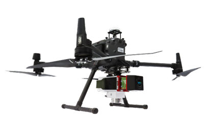
LiAir 250 Pro Lidar UAV: Mjas Zenith
image source: lidar.flightsinc.jp
The LiAir 250 Pro is an advanced LiDAR mapping system that combines high-precision LiDAR technology with powerful data processing capabilities. Designed for aerial surveying and mapping applications, the LiAir 250 Pro offers exceptional accuracy, efficiency, and versatility. In this blog post, we will address the frequently asked questions about the LiAir 250 Pro, providing valuable insights into its features, benefits, and applications.
What is the LiAir 250 Pro?
The LiAir 250 Pro is a professional-grade LiDAR mapping system that utilizes laser technology to capture highly accurate 3D point cloud data from the air. It consists of a LiDAR sensor, an inertial measurement unit (IMU), a global navigation satellite system (GNSS), and powerful data processing software.
What are the key features of the LiAir 250 Pro?
The LiAir 250 Pro incorporates several features that contribute to its exceptional performance:
- High-precision LiDAR sensor: The system is equipped with a high-resolution LiDAR sensor that captures millions of points per second with millimeter-level accuracy.
- Integrated GNSS and IMU: The GNSS and IMU provide precise positioning and orientation data, ensuring accurate georeferencing of the captured point cloud data.
- Lightweight and compact design: The LiAir 250 Pro is designed to be lightweight and compact, allowing for easy integration onto various unmanned aerial vehicle (UAV) platforms.
- Real-time data preview: The system provides real-time data preview during flight missions, allowing users to assess the quality and coverage of the captured data.
- Advanced data processing software: The LiAir 250 Pro comes with powerful data processing software that enables efficient point cloud classification, feature extraction, and geospatial analysis.
How does the LiAir 250 Pro enhance aerial surveying and mapping?
The LiAir 250 Pro offers several benefits that enhance aerial surveying and mapping workflows:
- High-accuracy data capture: The LiDAR sensor of the LiAir 250 Pro captures highly accurate 3D point cloud data, providing precise measurements for mapping, topographic surveys, and volumetric calculations.
- Efficient data collection: The system's high data capture rate and wide field of view allow for rapid data acquisition, enabling efficient coverage of large areas in a short amount of time.
- Versatile applications: The LiAir 250 Pro is suitable for various applications, including land surveying, infrastructure mapping, forestry, environmental monitoring, and urban planning.
- Enhanced safety and accessibility: Aerial LiDAR mapping with the LiAir 250 Pro reduces the need for ground-based data collection, allowing access to remote or hazardous areas while improving safety for surveyors and personnel.
- Detailed analysis and visualization: The powerful data processing software enables comprehensive point cloud analysis, feature extraction, and visualization, facilitating accurate decision-making and planning.
What industries can benefit from the LiAir 250 Pro?
The LiAir 250 Pro finds applications in various industries, including:
- Surveying and mapping: The system provides surveyors with accurate and detailed 3D data for mapping, topographic surveys, and construction site monitoring.
- Infrastructure and utilities: The LiAir 250 Pro assists in infrastructure planning, asset management, and inspection of utilities such as pipelines, power lines, and transportation networks.
- Forestry and environmental management: The system aids in forest inventory, biomass estimation, vegetation mapping, and environmental monitoring.
- Mining and quarrying: The LiAir 250 Pro enables volumetric calculations, stockpile management, and mine planning in the mining and quarrying industry.
- Urban planning and development: The system supports urban planning, city modeling, and monitoring of construction projects.
The LiAir 250 Pro is a powerful LiDAR mapping system that revolutionizes aerial surveying and mapping. With its high-precision LiDAR sensor, integrated GNSS and IMU, lightweight design, and advanced data processing capabilities, the LiAir 250 Pro offers exceptional accuracy, efficiency, and versatility. Whether you're a surveyor, engineer, or environmental specialist, the LiAir 250 Pro is a valuable tool for capturing highly accurate 3D point cloud data for a wide range of applications.


Comments
Post a Comment